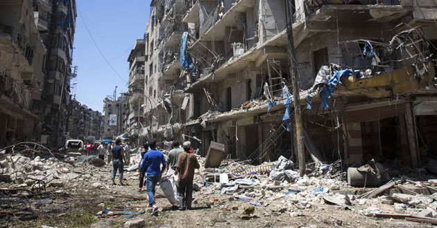
In November 2016, World Health Organization (WHO) condemned attacks on 5 hospitals in Syria
Since posting the original blog in early December, I have been working to promote the concept of a Digital Red Cross, through various networks, international agencies and NGOs. These discussions are ongoing, but in the meantime I’d like to provide the first in a planned series of updates in 2017; to flesh out the concept, deal with some of the arguments for and against, examine other options, and identify key stakeholders.
In this first update, the focus will be on:
- recent articles on attacks on health care workers;
- use of spatial technology in disaster, conflict and emergency situations: and
- more detail about the potential of blockchain technology for the humanitarian sector.
Recent articles on attacks on health care workers
In the January 2017 issue of the Bulletin of the World Health Organization, there are two articles on the subject of attacks on health care workers.
In ‘Attacks depriving people of urgently needed health care’, Jan Dirk Herbermann and Fiona Fleck interview key stakeholders (including from International Red Cross and Red Crescent Movement, WHO and MSF), and focus on the WHO data reports, the long term consequences of such attacks, and the importance of the international legal frameworks, Geneva Conventions, and the Rome Statute (the treaty that established the International Criminal Court in 1998). They highlight the need for ‘new strategies…to ward off deliberate attacks.’
In ‘Documenting attacks on health workers and facilities in armed conflicts’, authors from King’s College London and Karolinska Institute in Sweden report on a workshop held in London in December 2015 titled ‘ Eliminating violence against health workers: from theory to practice.’ Again, they stress the importance of systematic data collection, development of evidence-based context-specific guidelines, and building on current campaigns such as Health Care in Danger (ICRC) and Medical Care Under Fire (MSF).
My sense from reading this and other reports is that we have moved quickly from identifying the problem (it was raised at the World Health Assembly for the first time in 2014), to documenting its extent and trends, and exploring solutions that combine elements of awareness, international law, and country-specific approaches. What is missing however, and is the subject of these blog posts, is the full exploitation of new technologies and the consideration of new international verification systems.
Use of spatial technology in disaster, conflict and emergency situations
I have recently co-written an article with Peter Woodgate from the Cooperative Research Centre for Spatial Information titled ‘Spatially Enabling the Health Sector’. It provides an overview of developments in spatial technologies, which may be useful for the reader not familiar with GIS/spatial terminology, and how it might be further utilized in health care broadly.
Anders Lyseen and colleagues have also categorized 865 articles into four domains (spatial analysis of disease, spatial analysis of health service planning, public health, and health technologies and tools) in their 2014 article ‘A review and framework for categorizing current research and development in health related GIS studies’.
There is no shortage of material, textbooks and training courses on this subject, but I would recommend starting with one recent systematic review, titled ‘The impact of digital technology on health of populations affected by humanitarian crises: recent innovations and current gaps’, published in late 2016 in the Journal of Public Health Policy, by Sandra Mesmar and colleagues from the American University of Beirut and the Arab Digital Public Health Initiative. They identified 50 such technologies, many of them in the ‘spatial, geospatial, GIS, and spatial decision support system’ category, and some in the ‘hand-held devices and data entry’ category, organizing them according to the stage of the humanitarian cycle they were used in (preparedness, response and recovery). They found that they facilitated communication, coordination, and data collection/analysis, enabling timely responses in humanitarian contexts.
In particular, they found five initiatives in which GIS had been a ‘major game changer’. They found that GIS was used to portray areas of conflict through ‘live crisis maps’ (documenting intensity of conflict and numbers of people in need of assistance), to match supplies to service demands, to create warnings, to track population movements, to assist targeted communication via text messages and social media, and to inform logistics, coordination and evacuation.
Let me pick out a couple of examples to show the data sharing and skills available across the whole humanitarian sector. Data from the Libya Crisis Map produced by UN OCHA (Office for Coordination of Humanitarian Affairs) was integrated into the UN official 3-Ws (Who is doing What and Where) coordination framework, and spatial tools were also used extensively in the response to the Ebola outbreak. The work of the Humanitarian Open Street Map team is highlighted in the Mesmar article. The World Health Organization used ESRI Story Map Journal to present Ebola Situation Reports in their Global Ebola Response Monitoring and Mapping System. NetHope were on the ground in West Africa providing internet access to enable, amongst other things, communication and mapping. MapAction were involved early in the outbreak. And MSF-Switzerland deployed a GIS expert for the first time in the field in Guinea.
There are plenty of other case studies of GIS use in the 2013 World Disasters Report produced by IFRC, that was thematically titled ‘ Focus on technology and the future of humanitarian action.’ Indeed, WHO has been using GIS technology in one form or another since the early 2000s e.g. through the HealthMapper and Global Atlas programs. ESRI, the largest private sector geospatial company in the world, already partner the UN to assist with disaster, food security and climate change relief measures, produce data for UN Sustainable Development Goals (SDG), and to create an SDG Engagement Platform.
The brief overview above supports the contention that spatial technology is already utilized extensively in various parts of the health and humanitarian sectors, and that considerable expertise could be brought together from public, private and NGO sectors to assess its potential further contribution to preventing attacks on health care facilities and health workers.
More detail about the potential of blockchain for the humanitarian sector
Let me begin by saying again that I have no specific expertise in this area, and no shares whatsoever, let alone in any technology company!
But there are lots of extremely able technology professionals, who could provide a view on the potential of this and other technology options, should they be asked or ‘convened’.
The Digital Humanitarian Network (DHN) is a network of networks, aiming to create a bridge between volunteer and technical communities, and formal humanitarian organizations. It specializes in real-time monitoring, rapid geo-location of events and infrastructure data, GIS and big data analysis. In association with UN OCHA, it has produced two complementary guidance documents, one on ‘Collaborating with Volunteer and Technical Communities’ and the other on ‘Collaborating with Formal Humanitarian Organizations’, which taken together describe different types of organizational culture in the humanitarian sphere, and recommends ways to work together. And in 2015, it published ‘ Guidance for Incorporating Big Data into Humanitarian Operations’, examining the differences and complementarity of so-called Big Data, and traditional data.
DHN’s most recent report is ‘Blockchain for the Humanitarian Sector: Future Opportunities’ and has just been published with the support of UN OCHA in November 2016.
In this report, Vanessa Ko and Andrej Verity give an extremely clear overview of blockchain technology (‘a decentralized database that records transactions shared across a network of multiple participants’, and that provides information that is ‘transparent, traceable and secure’), and how it could be applied to a range of humanitarian challenges in information management, identification, supply chain tracking, cash programming and humanitarian financing. They highlight challenges (including internet access, scalability, and regulatory), as well as opportunities, and emphasise the need for well-evaluated pilots of this promising technology, which is still in an early phase of development. It may have a role to play in preventing attacks on health care facilities, because of its potential uses in establishing identity of infrastructure and health care personnel.
Going back to the Mesmar paper mentioned earlier. The authors highlighted the need for evaluation of all digital technologies, including through iterative action-research cycles and deep user feedback, and the creation of ‘a space for dialogue between technology designers and populations affected by humanitarian crises.’ It seems to me that a workshop convened with health, humanitarian and technology stakeholders present, might constitute such a ‘space for dialogue’. The purpose would be to develop options for an agreed system, bringing together existing ‘pieces’ of workforce and technology, which could then be trialled and evaluated. It would of course require political will and leadership, but in a year when we have a new UN Secretary General, and we will have a new WHO Director General, that is entirely possible.
As always, I’d appreciate comments, feedback, and offers of help to push this proposal forward, or to stimulate better options, via email to tarun.weeramanthri@bigpond.com
(I haven’t provided formal references in this update. If readers wish to access the articles and reports referred to, they are all free and online, and will appear in your preferred internet browser, through searching for the combination of authors and titles. If you have any problems, please contact me direct.)

One thought on “Digital Red Cross – update and more detail on spatial/technology aspects”